Geography
How cruise geography shapes your voyage
An itinerary looks like a series of choices. Most of it is what remained after the water, the coast and the infrastructure had ruled the other options out.
The short answer
Before an operator decides anything about a cruise, geography has already decided most of it. Distance divided by a ship's speed produces hours that must be spent moving. The shape of a coast decides whether ports can be strung together or must be reached across open water. Depth, berth length, canal dimensions, pilotage and quotas decide whether a place can be a stop at all. And the small number of ports capable of starting a voyage decides how far a given number of nights can reach.
This guide follows those four forces in order. The aim is that you can look at a region on a map and predict, before opening a single itinerary, roughly what kind of voyage it is able to produce.
By The SnapVoyages TeamPublished September 2026
The four forces
What is deciding before anyone chooses
These are not four factors to weigh against each other. They act in sequence: distance produces time, geometry produces shape, access filters the stops, and gateways bound the whole thing.
Force 1
Distance becomes time
Ports sit a fixed number of nautical miles apart.
Days at sea are a measurement of spacing, not a product feature. Widely spaced ports require more sailing time; closely spaced ports make full transit-only days less necessary.
Force 2
Coastline geometry decides route shape
Coasts, seas and island groups are arranged in a fixed way.
Route shape sets port density, and port density sets the ratio of moving days to stationary days without anyone choosing it.
Force 3
Access is a ship–place pair
Depth, berth length, lock and canal dimensions, anchorage, pilotage, quotas and emission rules are fixed properties of a place.
The same coordinates can be a full port call for one ship, an anchor call for another and unreachable for a third.
Force 4
Gateways set the radius
A major embarkation gateway needs sufficient marine and terminal capacity for the ships it turns around, plus surface transport and, for fly-cruise markets, practical air access.
A fixed number of nights defines a radius around a gateway. What lies outside that radius does not appear on short itineraries, however famous it is.
The usual way of describing itineraries starts downstream, at the finished product, and treats its properties as preferences — some people like sea days, some prefer packed port schedules. That reading misses where the properties came from. A region with ports two hundred miles apart cannot produce a week without significant time spent moving, and a region with ports fifty miles apart cannot produce one full of sea days. Nobody decided either.
Force 1
Distance becomes time, and time is subtracted first
A ship's service speed sits in a narrow band, so the distance between two places converts almost directly into hours the voyage no longer has.
1. Cause
Ports sit a fixed number of nautical miles apart.
2. Mechanism
A ship holds a narrow band of service speed. Distance divided by that speed produces a number of hours, and those hours are spent before any time ashore exists.
3. Consequence
Days at sea are a measurement of spacing, not a product feature. Widely spaced ports require more sailing time; closely spaced ports make full transit-only days less necessary.
Model spacings at an assumed 18 knots
These are illustrative figures, not measurements of any real pair of ports. 18 knots is used here purely as a worked assumption. Operators publish their own service speeds for their own ships; there is no single cruise-ship speed.
Tightly spaced coast
90 nm ÷ 18 kn ≈ 5 h
Approximately five hours of pure sailing time in this model, leaving substantial room within an overnight interval.
Moderately spaced sea
200 nm ÷ 18 kn ≈ 11 h
Approximately eleven hours of pure sailing time, enough to consume much of an overnight interval before approach and manoeuvring are considered.
Widely spaced basin
430 nm ÷ 18 kn ≈ 24 h
A full day of sailing. Whatever the brochure calls it, that day is at sea because the water between the two places has to be crossed.
Ocean crossing leg
1,700 nm ÷ 18 kn ≈ 94 h
Several consecutive days of movement. Nothing about the ship or the operator changes this; the distance does.
The arithmetic above is deliberately simple and deliberately illustrative. Real passages carry additional time for pilotage, manoeuvring, port approaches and weather margin, and operators vary speed for fuel and schedule reasons. But the direction of the relationship never changes: more water between two places means more of the voyage spent crossing it.
This is also why the phrase "day at sea" describes a measurement rather than an offering. When a region's ports are far apart, the sea day is what the distance looks like on a schedule. Where a specific voyage places those hours, and what that leaves you ashore, is the subject of how to read a cruise itinerary.
Sea days are a property of the map, not of the brochure
For comparable port sequences and similar operating speeds, geography imposes a similar minimum amount of sailing time. Operators can distribute or add to that time differently.
Force 2
The shape of the coast decides the shape of the route
Four arrangements of land and water recur around the world, and each one permits a different route figure. Port density — and therefore the rhythm of the week — follows from the figure.
1. Cause
Coasts, seas and island groups are arranged in a fixed way.
2. Mechanism
An enclosed sea, a sheltered linear coast, an island cluster and an open basin each permit different route figures — a ring, a line, a hub with returns, or an out-and-back across open water.
3. Consequence
Route shape sets port density, and port density sets the ratio of moving days to stationary days without anyone choosing it.
Enclosed sea, ports around the rim
A basin surrounded by populated coast, with ports spaced within a night's sailing of one another.
Route figure
A ring or arc that returns to its starting point.
What follows
High port density and few days without a call, because the geometry never requires a long crossing.
Sheltered linear coast
A long coast with an inshore route protected by islands, mountains or a fjord system, and towns strung along it.
Route figure
A line worked in one direction, often with a different port at each end.
What follows
Movement and scenery overlap: the passage itself is part of what the voyage is for, and the ship is rarely far from land.
Island cluster with a mainland gateway
A group of islands within short sailing distance of each other and of one large mainland port.
Route figure
A hub with a loop out and back, repeatable in several directions.
What follows
The same gateway can serve several different itineraries, and the distinction between them is which arc of the cluster is used.
Open water to a distant coast
A gateway separated from the destination by a stretch of open sea with nothing usable in between.
Route figure
An out-and-back, or a one-way leg with a flight at one end.
What follows
The crossing is fixed cost in time. The proportion of the voyage spent moving is set by the width of the water, not by the itinerary designer.
Why does route shape matter more than the number of ports?
Because the figure decides how much of the voyage is spent returning. A ring around an enclosed sea never has to retrace itself, so almost every leg is productive. An out-and-back across open water spends the same crossing twice, and those legs cannot contain a call because there is nothing between the two coasts to call at.
The consequence is that two regions can offer the same number of ports over the same number of nights and still feel structurally different, because one geometry keeps the ship near places and the other keeps it between them.
Force 3
Access is a property of the ship and the place together
A place is not simply reachable or unreachable. It has an envelope — depth, length, dimensions, rules — and each ship either fits it or does not.
1. Cause
Depth, berth length, lock and canal dimensions, anchorage, pilotage, quotas and emission rules are fixed properties of a place.
2. Mechanism
Each of those is an envelope. A vessel either fits it or does not, and where it does not fit, either a smaller vessel goes instead or the call happens by tender, or not at all.
3. Consequence
The same coordinates can be a full port call for one ship, an anchor call for another and unreachable for a third.
Canal envelope
The Panama Canal publishes maximum vessel dimensions for its Neopanamax locks, including a maximum length of 370.33 m and a maximum draught expressed in tropical fresh water.
A shortcut between two oceans is only a shortcut for ships inside the published envelope. For anything larger, the two oceans are joined only by a route around a continent, which is a different itinerary entirely.
Canal envelope
The Suez Canal Authority's Rules of Navigation set maximum dimensions and publish a table pairing permitted beam against permitted draught.
A corridor is not one number. Beam and draught are traded against each other, so two ships of similar size can have different answers to the same passage.
Compulsory pilotage corridor
Australian regulation requires coastal pilotage for vessels above a stated length in the Great Barrier Reef and Torres Strait compulsory pilotage areas.
Where a reef narrows the navigable water, passage adds a mandatory operational step with its own timing. The route remains possible, but it is no longer free of scheduling constraints.
Quota-limited water
Entry to Glacier Bay is limited by federal regulation, with vessel entries allocated by type and season under the park superintendent.
Capacity here is legal rather than physical. Demand does not create more entries, so which ships appear in the bay in a given season is settled long before any itinerary is published.
Emission-restricted enclosed water
The Norwegian Maritime Authority has adopted zero-emission requirements for passenger ships in the World Heritage fjords, phased by ship size, with shore power required where available.
An enclosed waterway concentrates whatever a ship emits, so the rule follows the geography. Access becomes conditional on propulsion and on ship size rather than on berth availability.
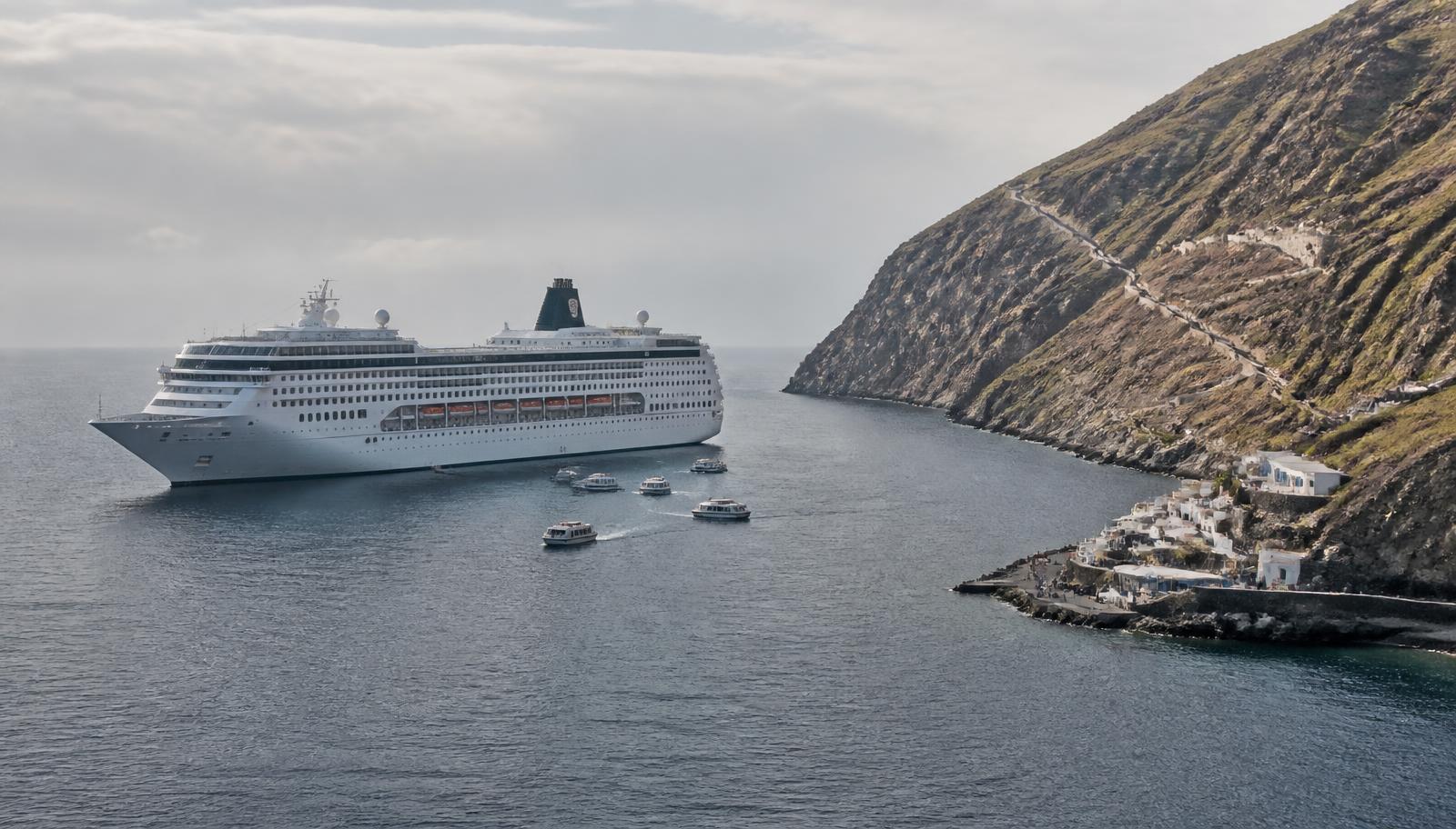
Anchorage instead of berth
Some harbours have no quay a large ship can lie alongside, and calls are worked at anchor with the ship's own boats.
Where the seabed drops away steeply or the harbour was built for small craft, there is nothing to build a berth against. The call still happens, but arrival and departure ashore are staged rather than immediate.
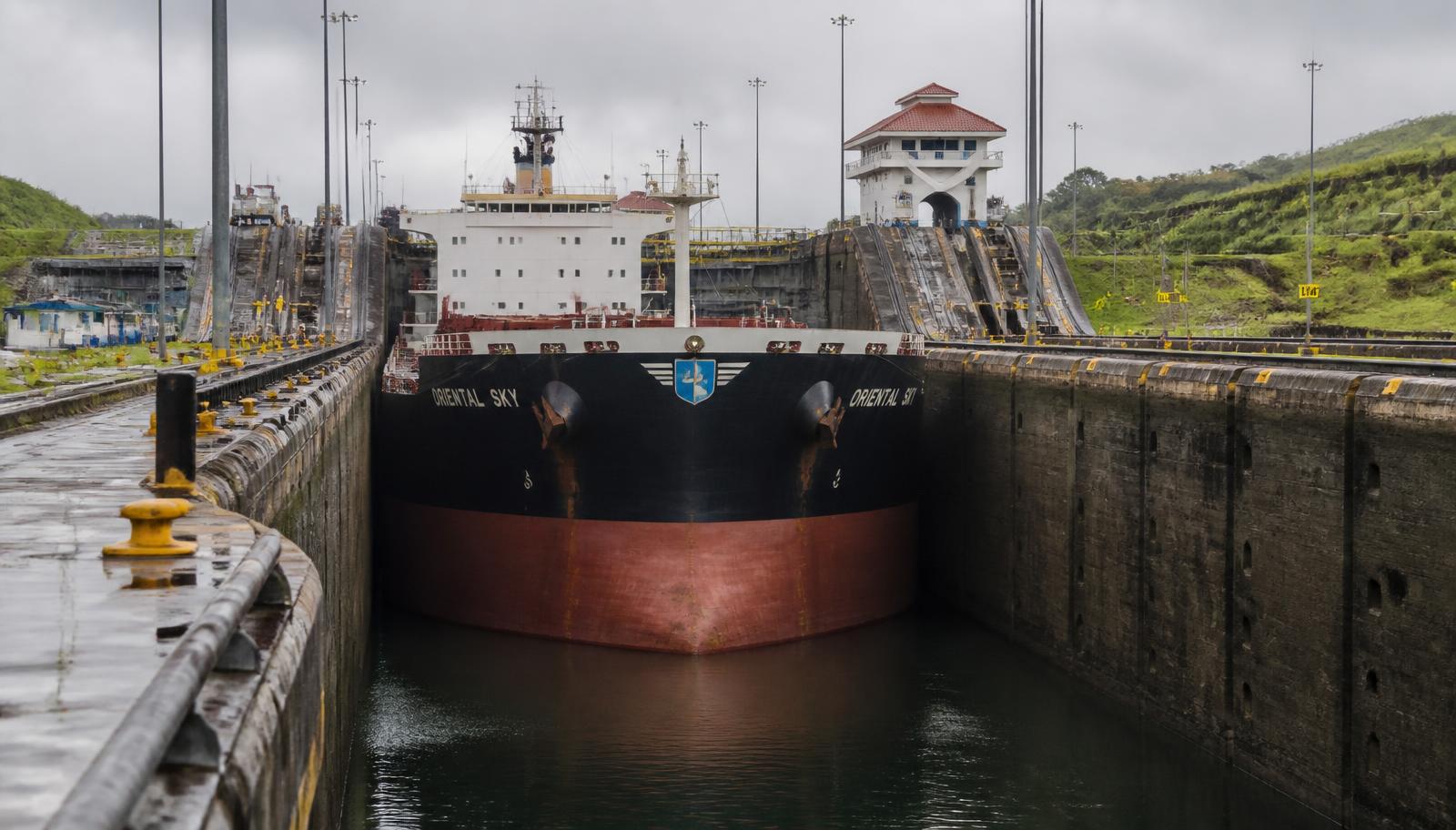
Where the envelope is dimensional — a lock chamber, a channel depth, a berth length — the filter is mechanical. Where it is regulatory — a quota, a pilotage requirement, an emission rule in an enclosed fjord — the filter is legal, but its effect on an itinerary is the same: only some ships can be scheduled there, and the schedule has to accommodate whatever the rule requires.
Note what this guide is not claiming. The existence of an envelope says nothing about what a larger or smaller ship is like to sail on. It says only that the envelope filters which ships can appear. What size changes for the people aboard is a separate question, and one this series takes up next.
Force 4
Gateways set the radius of everything
A voyage has to begin somewhere that can turn over an entire ship in a day and move its passengers in and out. Relatively few coastal cities can.
1. Cause
A major embarkation gateway needs sufficient marine and terminal capacity for the ships it turns around, plus surface transport and, for fly-cruise markets, practical air access.
2. Mechanism
Very few places on any coast hold all four at once, so voyages start and end at a small number of points rather than wherever the attractions are.
3. Consequence
A fixed number of nights defines a radius around a gateway. What lies outside that radius does not appear on short itineraries, however famous it is.
Requirement 1
Deep water and a long berth
A gateway must take the ship itself, which rules out most historic harbours regardless of how attractive the surrounding city is.
Requirement 2
Terminal capacity for a full turnaround
On a turnaround day a whole ship disembarks and a whole ship embarks. That needs baggage handling, security and immigration capacity concentrated into a few hours.
Requirement 3
Strong transport access
For fly-cruise markets, airport connectivity greatly expands the passenger catchment; in drive-to markets, road and rail access can perform much of the same gateway function.
Requirement 4
Provisioning, waste and crew logistics
Turnaround is also when the ship is restocked and crew rotate. That requires road access and suppliers, which is why gateways are usually working ports.
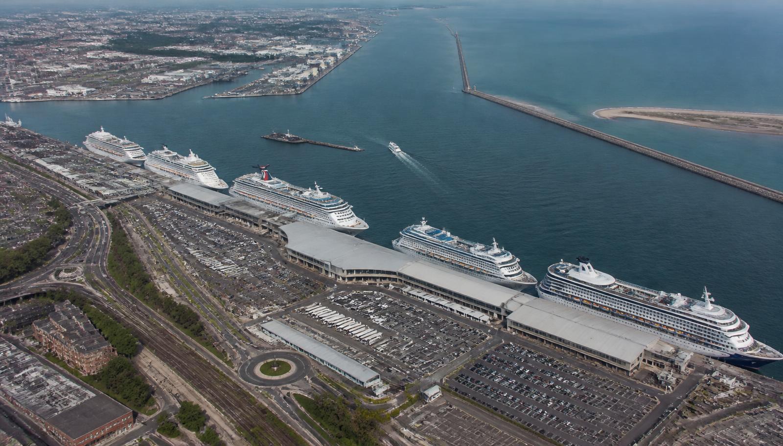
Once the gateways are fixed, the arithmetic of the first force takes over. A week from a given gateway can only reach what lies inside the distance the ship can cover and still return — or, where a second gateway exists, what lies along a one-way line between the two. This is why some celebrated places appear constantly on itineraries and others almost never: not because of their merit, but because of where they sit relative to a port capable of starting a voyage.
It is also why the same region can present quite differently depending on which gateway an itinerary uses. The set of places within reach turns with the starting point, and the geography of the region stays exactly where it was.
Where weather enters
Weather as an operational constraint, not a calendar
Conditions matter here only where they change what is physically possible on a given stretch of water.
Three cases belong in a geography guide. Exposed water: an open crossing has no shelter, so swell decides whether a passage is comfortable, slower than planned or diverted. Ice: ice can restrict or prevent navigation depending on its extent, concentration and the vessel's capability, and ships operating in polar waters are subject to specific design, equipment and operational requirements. Enclosed or shallow water: fog, wind and tidal range can close a narrow approach to a ship that could otherwise use it.
In each case the point is the same — weather acts on the geography, and the geography decides how much difference the weather makes. Open crossings are exposed because there is no land; fjords and reef corridors are sensitive because the navigable water is narrow. When each region actually operates, and why its season opens and closes, belongs to the seasons guide, and is not repeated here.
What this lets you do
Reading a region off a map
With the four forces in place, a map carries most of the information an itinerary is going to confirm.
| What the map shows | What follows from it |
|---|---|
| Ports are close together along a continuous coast. | Expect a high proportion of days with a call, and short overnight passages rather than full days at sea. |
| The region is a cluster of islands near one large mainland port. | Expect several different loops from the same gateway, and differences between itineraries that are mostly about which arc is used. |
| A wide stretch of open water separates the gateway from the destination. | Expect the crossing to occupy a fixed share of the voyage in both directions, or a one-way itinerary with a flight at one end. |
| The destination is an island with steep terrain and a small harbour. | Expect the possibility of an anchor call rather than a berth, and a call whose usable length depends on how the transfer is worked. |
| The route passes through a canal, strait, reef or enclosed fjord. | Expect a published envelope or a rule attached to that passage, and expect it to filter which ships can be scheduled there. |
| A famous place has no cruise port marked anywhere near it. | It is reached from a gateway elsewhere, which places it inside somebody's radius and outside somebody else's. |
None of this tells you where to go, and none of it ranks one geography above another. A crossing is not a worse week than a coastal loop; it is a different consequence of a different arrangement of water. What the four forces do is remove the surprise. When an itinerary shows two consecutive days at sea, or an anchor call instead of a berth, or a famous city absent from every routing in the region, there is a physical reason available, and it was usually visible on the map first.
The cruise atlas is the place to test that: regions, gateways, ports of call, river corridors and expedition operating areas drawn on the same base, so the spacing and the geometry can be seen directly.
Sources & verification
Physical and regulatory envelopes are cited from the bodies that publish them: canal authorities for canal dimensions, national maritime and park authorities for pilotage, quotas and emission rules, port authorities for berthing arrangements, and the IMO for polar certification. Distance and time figures on this page are illustrative model figures and are labelled as such.
- Panama Canal Authority — vessel requirements and Neopanamax dimensions — read 2026-09-01
- Suez Canal Authority — Rules of Navigation — read 2026-09-01
- Australian Maritime Safety Authority — coastal pilotage, Great Barrier Reef and Torres Strait — read 2026-09-01
- 36 CFR §13.1160 — Glacier Bay vessel quotas and operating requirements — read 2026-09-01
- U.S. National Park Service — Glacier Bay National Park and Preserve — read 2026-09-01
- Norwegian Maritime Authority — requirements for vessels in the World Heritage fjords — read 2026-09-01
- Norwegian Government — zero-emission requirements in the World Heritage fjords — read 2026-09-01
- Municipal Port Fund of Thira — Santorini ports — read 2026-09-01
- Municipal Port Fund of Thira — cruise ship berthing policy 2025–2026 — read 2026-09-01
- MSC Cruises — official website — read 2026-09-01
- International Maritime Organization — Polar Code — read 2026-09-01