Cruise systems
Ocean, river and expedition cruising
The three are usually presented as three tastes. They are better understood as three operating systems, each built by the water it runs on.
The short answer
The difference between ocean, river and expedition cruising is not principally a difference of style, price or ship size. It is a difference of constraint. A river lock has fixed dimensions; a polar landing site has a cap on how many people may stand on it; an ocean berth has a length and a depth. Those facts decide what can be built, where it can go, and what a day aboard it can contain.
This guide follows one chain — waterway, ship, access to land, daily rhythm, season, product boundary — through all three systems, and shows what necessarily changes at each link. It does not say which system is better, and it does not describe who each one is for.
By The SnapVoyages TeamPublished September 2026
The three systems
Start with the water, not the ship
Almost every comparison of these three begins with the vessel. That is the second link in the chain, and starting there makes the differences look like commercial choices when most of them are not.
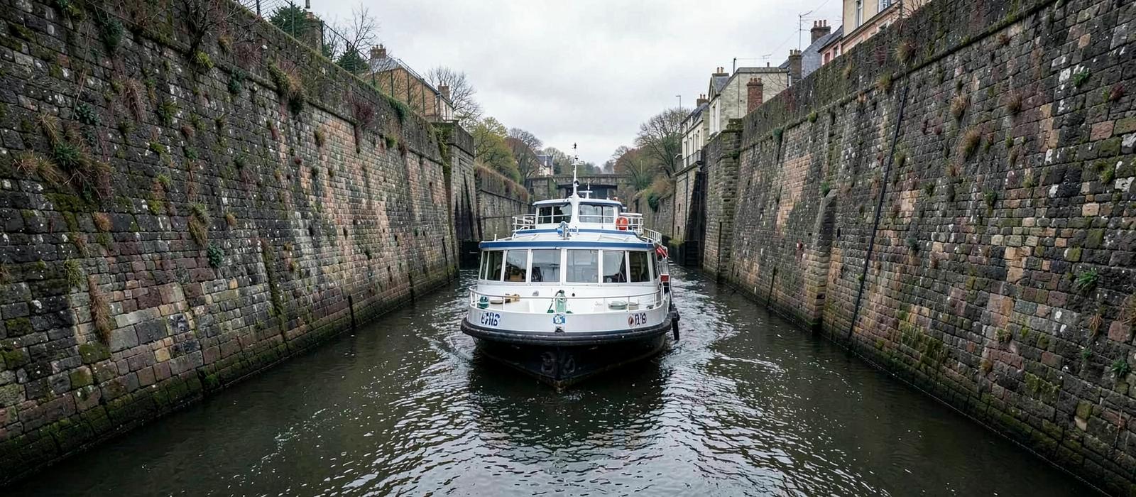
An ocean ship generally operates without a continuous fixed channel envelope; its strongest dimensional constraints tend to appear at ports, approaches and restricted passages rather than continuously along the route. A river vessel operates inside published infrastructure: a channel of stated depth, locks of stated chamber size, bridges of stated clearance. An expedition vessel operates where there is frequently no infrastructure at all, and where the right to be present is granted by a regulator rather than purchased from a terminal.
Those three situations produce three different machines, three different weeks and three different definitions of what has been bought. The rest of this guide is that argument, link by link.
Ocean
Open sea and coastal water, with calls at commercial seaports.
- What the ship can be
- Set by berth, draught and terminal capacity rather than by a fixed channel. CLIA describes a global fleet of roughly 350 ocean ships, around 70% of them small to mid-sized, so size is largely an operator's commercial choice within what the ports on the route can take.
- How it meets land
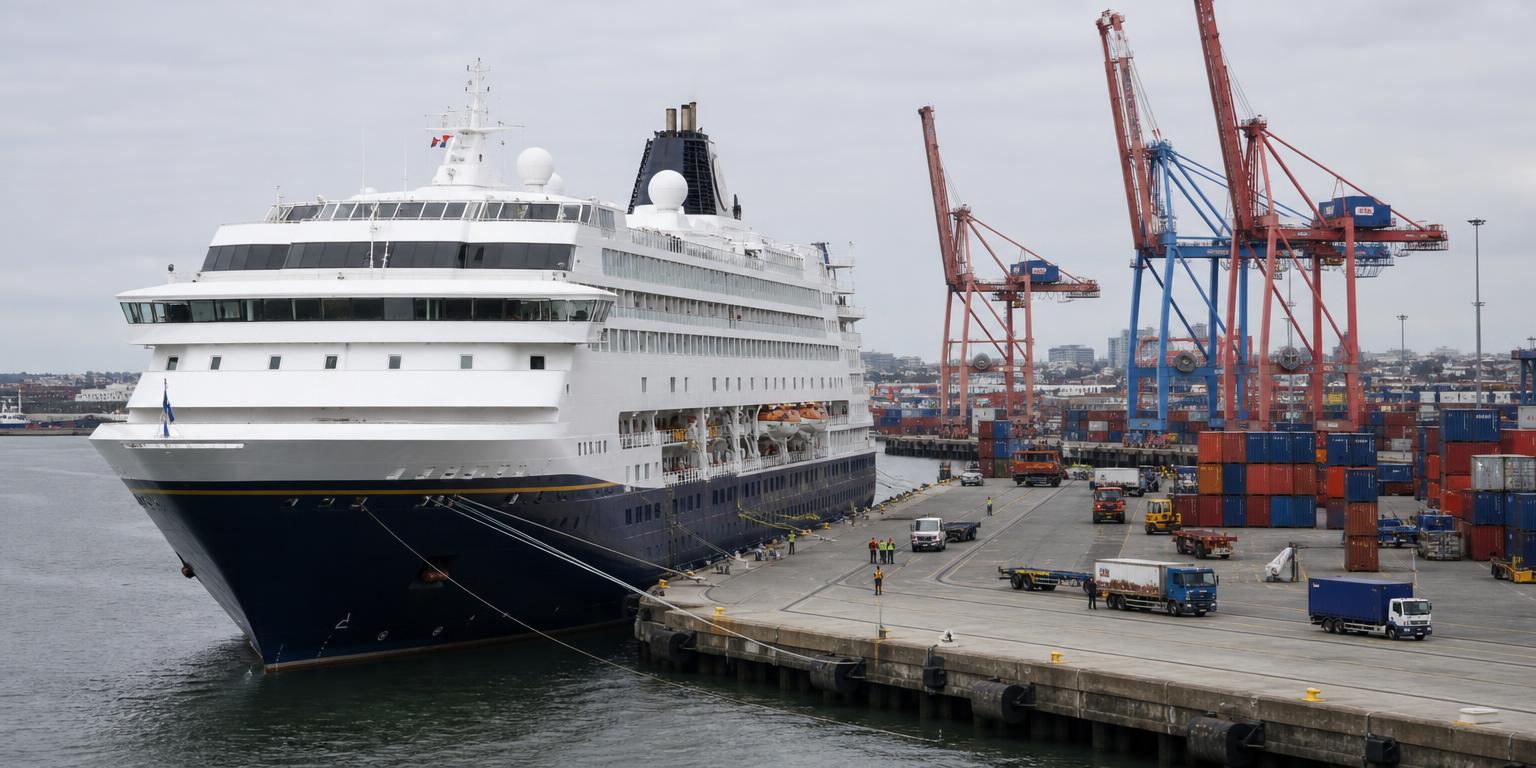
- Alongside at a berth where one is available and long enough; at anchor with tenders where it is not.
- Who else decides
- Flag and port state regulation, port authorities and terminal capacity.
River
Inland waterways: a channel of fixed width and depth, interrupted by locks and passed under by bridges.
- What the ship can be
- Set by the infrastructure, not by the operator. Lock chambers, bridge clearance and channel depth define a hull envelope, and vessels are built to fill it. Viking's standard European river ships are about 135 m long and carry 190 guests; AmaWaterways' AmaMagna is 443 ft long but 72 ft wide and carries 196 guests, and operates on the Danube.
- How it meets land
- Alongside a quay that can be within or close to the settlement, because the river was the transport corridor the town grew along; transfers are often shorter than from a distant commercial port.
- Who else decides
- Waterway administrations and river commissions that own the locks, publish the dimensions and set navigation rules.
Expedition
Remote coastal and polar water, often without any port infrastructure at the places the voyage exists to reach.
- What the ship can be
- Set by regulation and by the landing method. Ships operating in polar waters are built and certified under the IMO Polar Code, and in Antarctica the number of passengers a ship can put ashore is capped, so passenger numbers are an operating constraint rather than only a commercial decision.
- How it meets land
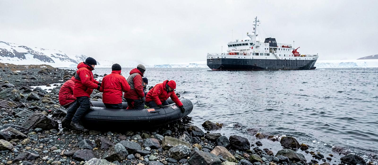
- By small boat. Guests transfer to inflatables to land on a beach or to cruise along an ice edge; where landing is not permitted or not possible, the small boat is the excursion.
- Who else decides
- The IMO Polar Code, the Antarctic Treaty system and IAATO's operating framework, and national park or environmental authorities in Svalbard, Galápagos and the Kimberley.
The method
One chain, followed three times
Each link is caused by the one before it. Read down a column and you are reading a system; read across a row and you are reading the same question answered by three different sets of physical facts.
One chain, followed three times
Each system answers the same six questions in order, and each answer is produced by the one before it. The differences between ocean, river and expedition cruising are almost all inherited from the first link.
Link 1
Waterway
What does the water itself allow?
Link 2
Ship
What can therefore be built and sent?
Link 3
Access to land
How do people get off the ship?
Link 4
Daily rhythm
What does that make a day look like?
Link 5
Season
When can the system operate at all?
Link 6
Product boundary
Where does the sold product stop?
Waterway
What does the water itself allow?
Ocean
Cause
No continuous fixed channel envelope; the strongest dimensional limits tend to appear at ports, approaches and restricted passages.
Consequence
Route design is a question of which ports a ship can enter and how far apart they are.
River
Cause
A channel with a published depth, locks with fixed chamber dimensions and bridges with fixed clearance.
Consequence
The route is constrained along a fixed corridor: a vessel must fit the limiting structures and navigable conditions along the itinerary.
Expedition
Cause
Water that is navigable but largely unserviced, and in polar regions seasonally covered by ice.
Consequence
The voyage has to carry its own means of reaching land, and the route is provisional rather than fixed.
Ship
What can therefore be built and sent?
Ocean
Cause
No single structural gate applies across a whole route.
Consequence
Ships span a wide range of sizes and layouts; CLIA reports around 70% of the ocean fleet is small to mid-sized.
River
Cause
The smallest lock, bridge and depth on the itinerary sets the maximum hull.
Consequence
Fleets converge on a template per waterway, and a wider or longer vessel is confined to the rivers that can take it.
Expedition
Cause
Polar Code certification, ice capability and passenger-landing rules apply to the ship itself.
Consequence
Vessels are built for capability and access rather than for scale, and capacity is bounded by what can be put ashore.
Where the constraint is written down
The dimensions are not the operator's to choose
These are the specific, published facts that make the chain concrete: lock and channel dimensions, certification requirements, landing caps and fleet composition.
The lock decides the hull
European river fleets are built to the waterway's envelope
Locks and channels on a river are published infrastructure with fixed dimensions, administered by waterway authorities and river commissions. A vessel that exceeds the smallest structure on an itinerary cannot run that itinerary, which is why fleets on a given waterway converge on a similar length, beam and air draught rather than on a similar price point.
One template, and its exception
About 135 m and 190 guests — unless the waterway allows more
Viking states that its standard European river ships are approximately 135 m long and carry 190 guests. AmaWaterways' AmaMagna is the same 443 ft length but roughly twice the beam at 72 ft, carrying 196 guests, and operates on the Danube. Two vessels of similar length differ sharply in what they contain, because beam is available on one river and not on others.
The landing limit shapes the ship
No more than 100 passengers ashore at one site at one time
Under the Antarctic Treaty system's site guidelines and IAATO's operating procedures, the number of passengers ashore at a landing site at any one time is capped. ATCM Measure 15 (2009) also prohibits landings from vessels carrying more than 500 passengers. A limit on landings is therefore a limit on how large a landing-based operation can usefully be.
The regulator specifies the ship
Polar operation is certified, not merely attempted
The IMO Polar Code sets mandatory requirements for ships operating in polar waters, covering ship design, equipment, operation, training and environmental protection. It applies as amendments to SOLAS and MARPOL, which makes polar capability a certification matter rather than an operator's description of its own vessel.
Access is granted, not booked
National authorities set where and how guests may go ashore
Svalbard's environmental regulation is administered by the Governor of Svalbard, Galápagos itineraries operate under national park regulation with licensed guides, and Kimberley coastal access involves marine park arrangements and Traditional Owner agreements. These are conditions on the operation, and they change what an itinerary can promise.
Scale is a choice within limits
Around 350 ocean ships, roughly 70% small to mid-sized
CLIA describes an ocean fleet of around 350 ships that varies widely in size, with the majority small to mid-sized. The constraint on any individual voyage is not a channel but the ports on it: berth length, draught and terminal capacity determine which ships can call, which is why the same brand can run very different vessels in different regions.
Access to land
How do people get off the ship?
Ocean
Cause
Berths are built for commercial shipping and are finite; some are far from the town.
Consequence
A call is alongside or at anchor, and the difference changes how much of the day is usable ashore.
River
Cause
The quay can be within or close to the settlement, because the river was the corridor the town grew along.
Consequence
Access can be on foot from the vessel, and transfer time is often shorter than from a distant commercial port.
Expedition
Cause
There is frequently nothing to tie up to.
Consequence
Landings are made by inflatable, in groups, subject to limits on how many people may be ashore at a site.
Why does the way a ship meets land change so much else?
Access is the point at which the geography of the water becomes the shape of the day. A vessel alongside a quay within or close to a settlement can deliver guests into the place on foot; a ship at a commercial berth some distance from the centre delivers them to a transfer; a ship at anchor delivers them to a tender operation that consumes part of the call at both ends; an expedition ship delivers them to a landing that is run in rotations because a site limit applies.
None of these is a service level. Each is what the available infrastructure permits. The consequence is that two voyages can allocate the same number of hours to a place and produce very different amounts of time in it — which is the arithmetic set out in the itinerary guide.
Daily rhythm
What does that make a day look like?
Ocean
Cause
Ports are separated by distances that take hours or a full day to cover.
Consequence
The week is a pattern of port days and sea days, and the ship is a destination on the sea days.
River
Cause
Towns are close together and the vessel can move at night.
Consequence
Sailing can take place overnight between relatively close calls, producing a rhythm with frequent arrivals and fewer full transit-only days than many ocean itineraries.
Expedition
Cause
What is possible depends on ice, wind, swell and site availability that morning.
Consequence
The day is planned and re-planned aboard, and the published itinerary describes intent rather than schedule.
A sea day is a distance, not a design decision
Ocean ports are separated by distances that take hours or a whole day to cover, so days at sea appear in the schedule. River towns sit close enough together that the vessel can move overnight, which is why a river week has a different shape rather than a slower one.
Season
When can the system operate at all?
Ocean
Cause
Weather systems close some regions seasonally, but the ship is mobile.
Consequence
Fleets redeploy between hemispheres and basins, so the ocean system rarely stops — it moves.
River
Cause
Water level and ice are properties of the route, and the route cannot be moved.
Consequence
The season is set by hydrology, and disruption within a season is a water-level question rather than a storm question.
Expedition
Cause
Ice and daylight open and close the operating area, and access can be permitted only in defined periods.
Consequence
Some operating areas have a single short season and no alternative window.
Why can an ocean region close and the ocean system keep running?
Because a ship is mobile and a river is not. When a weather season closes an ocean region, operators can move vessels to another basin or hemisphere, so the closure is a redeployment rather than a stop. A river's constraint is a property of the route itself: water level, ice and lock availability cannot be relocated, and a vessel built for one waterway's envelope may not be able to sail another.
Expedition operating areas add a third kind of limit. Ice and daylight define what is physically possible, and access to specific areas is governed by environmental and park authorities. Where those windows are narrow, the season is short and there is no alternative period to move into.
Product boundary
Where does the sold product stop?
Ocean
Cause
Ports have their own economies; food, drink, tours and connectivity can all be bought elsewhere.
Consequence
The fare can be drawn narrowly and the rest offered as purchases, though how narrowly varies by line and market.
River
Cause
Calls are short and the shore programme is closely tied to the sailing schedule.
Consequence
Operators often place the excursion programme inside the fare; the specific bundle is a line's own model, not a rule of the system.
Expedition
Cause
There is no local supplier of a zodiac landing, a guide or polar outerwear.
Consequence
The landing operation and guiding are normally part of the operator's product because there is no local supplier at the site; equipment may be included or loaned, while required insurance can remain a separate passenger cost.
Ocean
Commonly drawn around passage, cabin, main dining and most entertainment, with much of the onboard offer and the shore programme sold separately. It varies by line and market.
Season set by
Weather systems and redeployment. Tropical storm windows, winter weather and the fact that a ship can be moved to another ocean when the season closes.
Day set by
Alternating port days and sea days, because ports are separated by distances a ship covers overnight or over a full day.
River
Often drawn wider. Viking, for example, publishes a fare model including a shore excursion in each port, wi-fi and meal-time beer and wine. Other operators draw it elsewhere.
Season set by
Hydrology and ice. High water can prevent bridge passage, low water can prevent passage at all, and northern rivers freeze.
Day set by
Near-continuous movement between short stops. Distances between towns are small, so the vessel can sail while guests sleep and be somewhere new most mornings; locks are often transited overnight.
Expedition
Often drawn wider again, because the activity ashore cannot be bought locally. Operators such as HX supply outerwear and loan activity equipment; Quark requires passengers on its Antarctic voyages to hold insurance covering emergency evacuation.
Season set by
Ice, daylight and permitted access windows, which in some operating areas produce a single short season.
Day set by
Set by conditions on the day. The published plan names an operating area rather than a fixed sequence of arrivals, because ice, wind and site availability decide what happens.
The boundary of the product is the link readers most often mistake for a pricing strategy. Some of it is: how narrowly a mainstream ocean line draws the fare is a commercial decision, and it differs between brands and markets. But part of it is structural. A shore excursion in a river town is scheduled around a sailing time the operator controls, and an expedition landing has no local supplier at all — there is no one at a polar site selling a zodiac transfer, a guide or a parka.
The practical consequence is that two advertised figures from two systems are not two prices for the same thing. What differs is how much of the voyage is inside the number. The mechanics of that are set out in what a cruise really costs.
What follows
Reading a product by its system
Once the chain is visible, most of the practical differences between these three are predictable rather than surprising. The table states each property and the reason it exists.
| Property | Where it comes from | Why it is there |
|---|---|---|
| Calls that can be walked into | River | The quay can be within or close to the settlement because the river is the corridor the settlement grew along. It is a geographic fact, not a service level. |
| Whole days at sea | Ocean | Ports are far enough apart that crossing between them occupies a day. Sea days are a distance consequence, not a filler. |
| A day that can change on the morning | Expedition | Ice, wind and site availability are decided by conditions rather than by schedule, and the operator plans against them daily. |
| A wide range of ship sizes to choose between | Ocean | No single structure gates the route, so vessel size is limited by ports rather than by the water itself. |
| A season that can close because of the water level | River | Hydrology is a property of a fixed route, and a river cannot be redeployed elsewhere. |
| Most of the shore programme already inside the fare | River and expedition, depending on the operator | Where the activity is tied to the sailing or cannot be bought locally at all, operators commonly place it inside the product. This is a line-by-line model, not a guarantee. |
There is no verdict at the end of this, and adding one would misrepresent the material. Nothing in a lock dimension, a landing cap or a berth length tells you what someone should book. What it does tell you is which properties travel together: a system that often puts you close to the settlement on arrival is also a system with a hydrological season and a fixed hull envelope, and a system that reaches places without ports is also one that plans daily against conditions.
Those pairings are not marketing positions. They are what the water permits, and they are the reason the three cannot be collapsed into a single scale of size or price.
Sources & verification
Every constraint on this page is taken from the body that publishes it: waterway administrations and river commissions for channel and lock dimensions, the IMO and the Antarctic Treaty system for polar operation, national authorities for access rules, and CLIA for fleet-level figures. Cruise lines are cited only for facts about their own ships and their own fare models, and those models are theirs rather than industry rules.
- Cruise Lines International Association (CLIA) — read 2026-09-01
- CLIA / Tourism Economics — Contribution of Cruise Tourism to the Global Economy — read 2026-09-01
- Central Commission for the Navigation of the Rhine (CCNR) — read 2026-09-01
- viadonau — Austrian waterway administration — read 2026-09-01
- Wasserstraßen- und Schifffahrtsverwaltung des Bundes (Germany) — read 2026-09-01
- viadonau DoRIS — Danube lock status — read 2026-09-01
- APDL — Douro navigation channel and locks — read 2026-09-01
- International Maritime Organization — Polar Code — read 2026-09-01
- IAATO — International Association of Antarctica Tour Operators — read 2026-09-01
- Secretariat of the Antarctic Treaty (Visitor Site Guidelines and ATCM measures) — read 2026-09-01
- Sysselmesteren på Svalbard (Governor of Svalbard) — read 2026-09-01
- Dirección del Parque Nacional Galápagos — read 2026-09-01
- Western Australia Department of Biodiversity, Conservation and Attractions — read 2026-09-01
- Viking — official website (inclusive value) — read 2026-09-01
- AmaWaterways — AmaMagna (official ship specification) — read 2026-09-01
- HX (Hurtigruten Expeditions) — official website — read 2026-09-01
- Quark Expeditions — official website — read 2026-09-01
- Lindblad Expeditions — official website (expedition cruising) — read 2026-09-01
- Royal Caribbean International — official website — read 2026-09-01