Seasons
Caribbean cruises in hurricane season
Half the Caribbean cruise year falls inside the Atlantic hurricane season. Whether that matters depends on three things you choose: the month, the part of the Caribbean, and how much of the trip depends on a fixed plan.
The short answer
Yes, if you can accept a changed itinerary. Ships keep sailing from 1 June to 30 November; when a storm threatens, the ship moves away from it and ports are swapped, reordered or replaced with sea days. Being caught at sea in a hurricane is not the realistic outcome. Losing the islands you booked for is.
The exposure is uneven. NOAA's long-term record puts the peak on 10 September, with most activity between mid-August and mid-October, and in that window the densest storm tracks cross the eastern Caribbean and the Bahamas. June, July and November carry much less, and the ABC islands in the south lie off the main tracks — less exposed, never immune.
By The SnapVoyages TeamPublished October 2026
The verdict
Who this season suits, and who should pick another
Reasonable to book
If the cruise itself is the holiday
- You would be content with a different island, or an extra sea day, at short notice.
- You can arrive at the home port a day early and have some slack on the way home.
- You choose June, July or November, or an itinerary in the western or southern Caribbean in the peak weeks.
- You have checked the line's itinerary-change terms and bought any insurance as soon as you booked.
Better in another season
If a specific place or date is the point
- A wedding, a dive trip, a family meeting or a once-only excursion depends on one particular port.
- Flights, hotels and excursions are booked separately and are hard to change or refund.
- You would be travelling in the peak weeks on an eastern Caribbean or Bahamas itinerary and would mind losing ports.
- A forced change of plan would spoil the trip rather than merely alter it.
You trade predictability for the same ships, routes and season
Nothing in this guide can make a sailing safe from change. It can show where and when change is more or less likely, and what it would cost you.
The calendar
How the season builds and fades, month by month
The official season is the same every year. The weight of activity inside it is not evenly spread.
- Official season1 June – 30 November
- Most activitymid-Aug – mid-Oct; peak 10 Sep
Dates from NOAA's National Hurricane Center. The period of most activity describes the long-term record, not a forecast for any year. Storms can and do form outside the official season.
| What the record shows | Where storms tend to be | What it means for a cruise | |
|---|---|---|---|
| June | The first named storm of an average season forms in mid to late June. Activity is low. | Mostly the Gulf, the western Caribbean and off the US south-east coast. | The lowest-exposure month of the season for the eastern and southern Caribbean. Heat and showers, not storms, are the usual weather story. |
| July | Still before the busy part of the season. | A thin band across the southern Windward Islands and around Florida and the Gulf. | Changes are possible but uncommon. Summer school-holiday demand, not storms, shapes availability. |
| August | The first hurricane of an average season forms in early to mid-August; the most active period begins mid-month. | Long tracks from the tropical Atlantic across the Leeward Islands, Puerto Rico and towards the Bahamas. | From mid-August, eastern Caribbean and Bahamas itineraries are the ones most often reworked. |
| September | The historical peak, 10 September. The first major hurricane of an average season forms in late August or early September. | The widest spread of the year: the eastern Caribbean, the Bahamas, the Gulf and, to a lesser degree, the western Caribbean. | The month with the highest exposure. Read any itinerary as a likely shape, not a fixed list. |
| October | Activity remains significant until about mid-October, then declines. | Activity shifts west: the western Caribbean, the Gulf and Florida see more than the eastern islands. | Western Caribbean routes carry more of the exposure than in August; eastern routes carry less. |
| November | Activity is usually low, but late-season storms do occur. | Mainly the western Caribbean and around the Bahamas. | Close to the winter pattern by late November, though the season formally runs to the 30th. |
Seasonal dates and the progression of an average season (1991–2020: 14 named storms, 7 hurricanes, 3 major hurricanes) from NOAA. A single year can be far busier or quieter than the average, and an early or late storm can affect any one sailing.
A busy basin is not the same as a disrupted cruise
NOAA's figures describe the whole Atlantic basin: the open ocean, the Caribbean Sea and the Gulf. Many storms never come near a cruise route, and a storm hundreds of kilometres away can still change one, because ships reposition days in advance to keep their distance.
So the useful question is not how many storms a month brings, but where they typically travel in that month and whether your itinerary lies across that path. That is what the next section shows.
Geography
Eastern, Western or Southern Caribbean?
The same week can be busy on one side of the Caribbean and quiet on the other. This is where the choice of itinerary does real work.
Storms passing within 150 nautical miles, per 100 years (NOAA, 1944–2020)
| Itinerary region | Jun | Jul | Aug | Sep | Oct | Nov |
|---|---|---|---|---|---|---|
| Eastern CaribbeanReference point: St. Thomas / San Juan | <10 | <10 to 29 | 50 to ≥70 | 50 to ≥70 | 10–29 | <10 |
| BahamasReference point: Nassau | <10 | <10 to 29 | 30–49 | 30–69 | 10–29 | 10–29 |
| Western CaribbeanReference point: Cozumel / Grand Cayman | <10 to 29 | <10 | 10–29 | 30–49 | 30–49 | 10–29 |
| Southern CaribbeanReference point: Curaçao | <10 | <10 | <10 | <10 to 29 | <10 to 29 | <10 |
Method: SnapVoyages read the colour band at one reference point per row from the NOAA National Hurricane Center monthly climatology maps (shown below). These are images, not machine-readable data, so each cell is a colour band, never an exact count; a range means the point sits on a band edge. NOAA's maps count named storms (tropical storms and hurricanes together) whose centre passed within 150 nautical miles of a point, scaled to a 100-year rate from the 1944–2020 record. A point value does not describe a whole region, and it measures how often storms have passed nearby — not the chance that a given cruise is changed, which also depends on forecasts, ship routing and the operator's decisions.
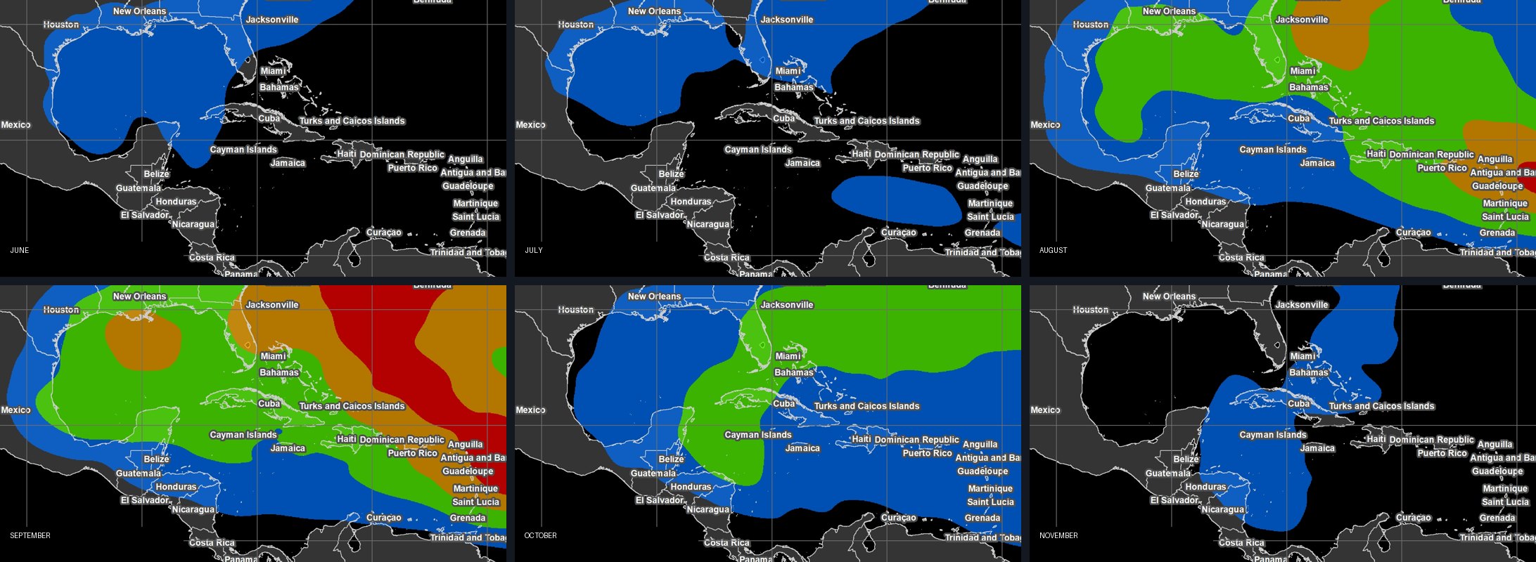
- Eastern Caribbean and Puerto Rico
- Lies across the classic path of storms that form over the tropical Atlantic and move west. Quiet in June and July, the most exposed part of the Caribbean in August and September, and calmer again from October.
- Bahamas
- Short cruises from Florida often call here. Exposure rises from August, with September the most active month. These itineraries are short, so one swapped call can be a large share of the trip.
- Western Caribbean
- Less exposed than the east in August, but storms also form or strengthen here, notably early and late in the season. October is relatively busier here than in the east.
- Southern Caribbean (ABC islands)
- Aruba, Bonaire and Curaçao lie south of the main storm paths and show the lowest counts throughout. They are less often directly affected, not never — and ships reach them past waters that are more exposed.
The subregions, home ports and typical routes are set out on the Caribbean page.
Operations
What actually happens when a storm threatens
A cruise line watches official track forecasts and decides days ahead where the ship can safely be. The decision is about distance from the storm, not about whether a port is open. A port in sunshine can be dropped because the ship cannot reach it and still keep clear of a system moving across its route.
- Ports swapped
- The most common change: one island is replaced by another on the far side of the storm, often at short notice.
- Order changed
- The same ports, visited in a different sequence, sometimes reversing the whole route.
- Sea days added
- A call is dropped and the time is spent at sea, sometimes because no alternative port can take the ship.
- Departure or return moved
- If the home port is threatened, boarding can be delayed or brought forward, and a return can be delayed or diverted to a different port.
- Flights disrupted
- Storms that close airports affect guests who are still on their way to the ship, and a ship cannot wait for late arrivals.
- Excursions lost
- An excursion booked for a port that is dropped does not happen. Whether you get your money back depends on who sold it.
These are the possibilities. On most sailings in the season, none of them happen; when one does, a swapped port or an extra sea day is far more typical than a changed home port.
Illustrative examples
Three travellers, three different answers
Hypothetical plans, not documented incidents. They show how the same season can be a sensible or a poor choice.
Hypothetical A
Booked for one island
- The plan
- An eastern Caribbean cruise in mid-September, chosen because of a pre-booked dive day on one particular island.
- Where a storm bites
- The plan rests on a single call in the most exposed region at the most exposed time. If that port is swapped, the reason for the trip disappears.
- A reasonable choice
- Move the trip to winter or spring, or book a land stay on the island instead. A cruise is a poor way to guarantee one place in September.
Hypothetical B
Flexible about where
- The plan
- A week from Florida in late June or early November, chosen for the ship and the sea days rather than any island.
- Where a storm bites
- Low basin activity and few hard commitments. A swapped port changes the scenery, not the value of the trip.
- A reasonable choice
- A reasonable booking. Arrive the day before, read the line's terms, and treat the published ports as the likely plan.
Hypothetical C
Everything booked separately
- The plan
- Cheap one-way flights, a non-refundable hotel night and three independent excursions for a western Caribbean cruise in October.
- Where a storm bites
- Every independent booking is a separate contract that the cruise line does not stand behind. A delayed embarkation or dropped port leaves each one to be sorted out individually.
- A reasonable choice
- Choose refundable or changeable bookings, fly in a day early, and check whether excursion operators refund for a missed ship. Insurance bought at booking matters most here.
Money and contracts
What you might lose, and who is responsible
What follows is how the pieces fit together. The contract you sign and the law where you book decide the actual outcome.
| What usually governs it | What to check | |
|---|---|---|
| Itinerary changed or port missed | Cruise contracts generally let the operator change ports for safety. A changed itinerary is usually not a cancelled cruise. | Whether port-specific taxes and fees for a dropped call are refunded, and whether any on-board credit is offered. |
| Voyage cancelled by the line | The operator's terms set the refund or future-cruise credit. For packages sold in the EU, an organiser that cancels for unavoidable and extraordinary circumstances must refund in full. | Refund versus credit, the deadline to choose, and what happens to flights booked through the line. |
| Significant change before departure | Under the EU Package Travel Directive, a traveller offered a significant change to a package can accept it or terminate without a fee. | Whether your booking is a package under the law where you bought it. |
| Missed embarkation after a flight delay | With flights booked independently, the ship is not obliged to wait. Air booked through the line is often treated differently. | The line's policy for guests on its own air, and your insurance's missed-connection cover. |
| Independent excursions and hotels | A separate contract with each provider. The cruise line is not responsible for them. | Each provider's refund rule for a missed ship or dropped port. |
| Travel insurance | Policy wording. On many policies a storm becomes a 'foreseen event' once it is named, and new policies then exclude it. | Buy cover when you book, not when a storm appears, and read what counts as a covered reason. |
Not legal advice. Entitlements differ by country, by the line's terms and by whether the cruise was sold as a package. Nothing here promises a refund or rules one out.
The booking decision
Matching month and itinerary to your tolerance
| Lower-exposure choices | What you accept | |
|---|---|---|
| Specific ports matter a great deal | December to May, or June–July outside the peak. In the peak weeks, the southern Caribbean. | Higher demand in winter; fewer itinerary options in the south. |
| You want the eastern Caribbean | June, July, November; late October onwards rather than late August to September. | Shoulder-season weather: heat and showers in summer, the tail of the season in November. |
| You want the western Caribbean | June to mid-August, or late November. | Some storms form or strengthen here early and late in the season. |
| Your dates are fixed in September | A southern itinerary, a flexible attitude to ports, a day's buffer at each end. | The highest basin-wide activity of the year, whichever route you choose. |
| Your travel is hard to change | Air and transfers through the line, or refundable independent bookings; insurance bought at booking. | A higher up-front cost for flexibility you may not use. |
Reader questions
The follow-up questions
- Is it dangerous to be on a cruise ship in hurricane season?
- The realistic risk is disruption, not danger. Ships are mobile and move away from forecast tracks days in advance; that mobility is exactly why itineraries change.
- Will the cruise line tell me in advance?
- Changes are usually announced once a forecast makes them necessary, which can be a few days ahead or during the cruise itself. Lines notify guests through their own channels.
- Are sailings in hurricane season cheaper?
- Fares follow demand, and late summer and autumn often have less of it than winter. That is a pattern, not a rule; compare the specific sailing.
- Does the season affect cruises outside the Caribbean?
- Bermuda, the US east coast and New England–Canada routes in autumn sit under the same Atlantic season. Other cyclone seasons are covered in cruise seasons worldwide.
In short
A decision about flexibility, not courage
Hurricane season does not stop Caribbean cruising; it makes the itinerary less certain, and the uncertainty is concentrated. Late August to mid-October on eastern Caribbean and Bahamas routes carries the most of it; June, July and November carry the least; the southern Caribbean is the least exposed region throughout, and the western Caribbean takes a larger share in October.
If you can treat the ports as a likely plan and protect the bookings around the cruise, the season is a reasonable choice. If the trip depends on one island, one date or a chain of non-refundable arrangements, choose another month.
Sources & verification
Season dates, the progression of an average season, the 10 September peak and the monthly storm maps from NOAA; the regional table is SnapVoyages' reading of those maps. Package-travel rights from the EU directive. Insurance practice from an insurance comparison service and stated as a common pattern; individual policies differ. Operator behaviour is described in general terms; each line's own terms apply.
- NOAA National Hurricane Center — Atlantic hurricane season climatology — read 2026-09-01
- NOAA AOML Hurricane Research Division — hurricane season FAQ — read 2026-09-01
- NOAA National Hurricane Center — tropical cyclone climatology and typical formation areas by month — read 2026-10-10
- Directive (EU) 2015/2302 on package travel and linked travel arrangements — read 2026-09-01
- Squaremouth (travel insurance comparison) — when a storm is considered a foreseen event — read 2026-09-01